
ABOVE: This is an artist's impression of what the OneBrighton project will look like when completed. I have to say that now it is actually nearing completion (January 2010), it does actually measure up to the picture quite well.
Image owned by onebrightoncasestudy.com
********************


Above and left: These two photos show Martha’s Barn Furniture Store, Cifford's Auto Factors and John's Camping Store as they appeared in March 2003.
The view to the left of the text shows the access ramp to the old car park rising gently before the point where it traverses the track bed to the Lower Goods Yard.
The open area between the ramp and Mocatta House (the large block in the centre of the photo) was owned by Harvest Forestry at this time and was given over largely to heaps of compost or topsoil, as seen just beyond the ramp.

ABOVE: The southern end of Martha’s Barn, looking roughly west. This location can be seen in the photo just above it, halfway down the left hand edge of the photo. In the background, the roof of Brighton Station is undergoing renovation, which dates the photo at 1999 or 2000.

ABOVE: This photo is taken from the rear of the Fyffe's Bananas Warehouse (later Clifford's Auto Factors, Martha's barn Furniture and John's Camping immediately prior to demolition), in 2000. In the present day this is the car park at the rear of OneBrighton.


ABOVE & BELOW: One of the most photographed buildings in Brighton in its day, the Locomotive Works access way, stairs and clocking on office stood just to the left of the CCK (Church of Christ the King) building with its distinctive white curved roof. The clocking on office was the very first step in the redevelopment of the site. Note the excellent view of the pillars (seen bottom right) which held up the extension of the Loco Works above the Lower Goods track bed. The footbridge seen here also crossed the same track bed. The roof seen bottom left is the northern corner of Fyffes Banana Warehouse, which will be known at the time of the photo as John's Camping.


ABOVE LEFT & RIGHT: Now you see it.............................................. now you don’t. Martha’s Barn, Clifford's and John's Camping Store bite the dust – the photo dates are roughly a year apart: March 2003 and 2004 respectively.

ABOVE: This photo shows the site of (from left to right) the access steps to the Works complex and associated ancilliary buildings, John’s Camping, Martha’s Barn and Clifford Auto Factors, in the process of demolition in 2004. The site was little more than a vast flat canvas for about 6 months after, but this area was extensively excavated and remodelled over the next 4 years. In the present day, the site is home to blocks E & F of the New England Quarter redevelopment, namely OneBrighton.

ABOVE: As the debris of demolition is gradually cleared away, the extent of the scale of the site starts to become apparent.

ABOVE: Over the next 3 months, a massive operation was undertaken to insert concrete piles (seen here as the upright tubes around the inclining ramps) to retain earth and form the basis for access roads. The area inside the confines of the piles was gradually excavated over a period of about 3 or 4 months. This photo actually dates from 24th April 2007 and illustrates how long this part of the site remained undeveloped for.

ABOVE & 2 BELOW: Plans of what the OneBrighton Development (the project planned for the majority of the site of Martha’s Barn/Cliffords/John’s Camping) will look like when completed. Both views show the profile as viewed from the station side, looking due west. Effectively, what you see here is facing in the opposite direction to John’s Camping et al, so this frontage would be to the rear of the site seen in photos previously.
All 3 images owned by NPA Consulting and appear at www.npaconsult.co.uk


ABOVE: Map showing how the entire site of the Brighton Railway Works complex will be made up, once redeveloped. The OneBrighton development blocks (John’s Camping et al, as it was) are in the area of Blocks E and F.

ABOVE: A massive amount of earth moving was undertaken in the early stages of redevelopment. At the time of writing (November 2012, the area immediately in front of the station in this photo(Blocks H & J) is yet to be developed. However, a development named City View is proposed for this area and looks likely to be built with little opposition or concern.
BELOW: This photo shows the site in August 2005. Note that the curve is artificial, as this is a panoramic photo: City College tower is seen to the left, New England House’s balcony to the right.


ABOVE: Clean canvas: the site of what will one day become CityPoint and Sainsburys is clear and ready for setting out. The end of the fence in the centre bottom edge of the photo was the gateway next to Cliffords.

LEFT: After around 3 years undeveloped the former site of Cliffords and Martha’s Barn sees some action. The height of the cranes on the site prior to construction is usually a pretty good indication of the scale of the building to be constructed.

ABOVE: Finally, work starts on the One-Brighton Development. This is actually the first floor being created in this photo.
Note the buildings in the background: these are the Eco Houses and are covered in detail elsewhere in this text.
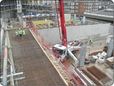
ABOVE & BELOW: Reinforced concrete construction at OneBrighton, for the ground and first floors. The top photo is looking due north-east, the one below is looking roughly south.


ABOVE & BELOW: More concrete being poured. This photo (above) shows the southern of the two blocks and is looking due north towards New England House in the background. Ditchling Road, Roundhill and Hollingdean can be seen in the background in the photo below, which is looking roughly north-east.


ABOVE & BELOW: The majority of the structure of the 2 blocks is complete here, with just the structure of the top floor to be constructed. This is quite interesting because the it is of lightweight construction and the floor plan has no bearing on the preceding floors. It sounds odd and as though it might look "stuck on as an afterthought, but it actually looks very good. The block walls are going in here - and appear to be made of compressed or reconstituted brick.


ABOVE & BELOW: The front of the two blocks of the OneBrighton development, viewed from the top floor of New England House (at great personal peril, because I am none too good at heights!) Above is looking due southwest and below is looking due north-west. The Eco Houses can be seen on top of the pillars that originally supported the extension of The Works Building.


LEFT: The OneBrighton tower begins to take shape with the outer walls and rendering creeping their way up the skeletal frame.

ABOVE: Reinforced framework is being put into place to form one of the floors, prior to concrete pouring. This view is looking North and the former path of the Lower Goods Track bed can just be seen in the top left hand corner.

ABOVE: Windows in and rendering completed, the shroud of scaffolding starts to come down.

ABOVE: This is the front of OneBrighton as viewed from New England Street. The curve of the picture is artificial and is much less pronounced in reality. However, it clearly shows the close proximity of the Citypoint tower on the left and New England House on the right. Just beyond the tree on the opposite side of the road would be CCK.

ABOVE & BELOW: These views show the rear of the block with the tower, looking from the base of the "Flat-Iron" building at the southern end of the block of Eco Houses set atop the pillars which originally supported the raised extension to The Works building.


ABOVE: This photo shows the view looking towards Preston Circus from the bus stop in Fleet Street. I particularly like the fact that it clearly shows several different facets of the redeveloped site. From left to right are The Jury's Inn, The Eco Houses, OneBrighton Development, New England House and last but not least, The Citypoint Development.

ABOVE & BELOW: These are two views of the rear of the blocks on the New England Street side. These photos are taken from the forecourt of The Jury's Inn


ABOVE: A view looking due south towards the Preston Road viaduct. This photo shows the close proximity to the Lower Goods Yard trackbed - the Eco Houses which have been constructed on top of the support pillars for the Railway Works Extension out over the trackbed are just visible in the top left of the photo.

ABOVE: This is the view looking due north towards the viaduct over London Road. The CCK building is clearly visible to the left of the photo. The path of the Lower Goods Yard trackbed is just off the left of the photo, whilst New England Street would be on the right, curving round to the left, behind the buildings. The concrete walls look a little stark in their current "just finished" state, but there is a good amount of planting in this location and once the concrete has weathered and the plants have grown out and settled down, it could look quite nice.

ABOVE: Looking south towards the OneBrighton Tower. The lit area next to the staircase is a community centre. A great amount of attention to detail has been paid to this communal area: there is a pre-eminent ecological theme which runs through this development and this is very evident in the diverse array of recycling options around the communal bins - If it can be recycled, it WILL be recycled! There is a particularly interesting feature of a rock wall for climbing attached to the wall just to the right of the staircase and slope.

ABOVE: The rear view of the 2 blocks looking from the car park at the rear of the CCK building, looking south.

ABOVE & RIGHT: Viewed in the present day: The OneBrighton flat-iron tower can be seen dominating the left of the photo, with the City Point tower just to the right. At the time of writing (22nd August 2013), The Super B development is gradually being constructed immediately in front of the chain link fence seen in this photo.
The OneBrighton tower is seen (left & below) looking roughly north-east here, completed, in 2013 on the left and north in the (Computer Generated) view below. Image owned by onebrightoncasestudy.com


BELOW: Floor plans of apartments from the OneBrighton development.


********************
Further resources for the OneBrighton Development:
http://onebrightoncasestudy.com/case-study/