NB: THIS PAGE IS STILL UNDER CONSTRUCTION

THERE MAY BE ERRORS, INCOMPLETE LINKS, TEXT MISSING AND IT MIGHT NOT MAKE MUCH SENSE! BUT PLEASE KEEP POPPING BACK, I'M ALWAYS ADDING NEW BITS.

ALSO, IF ONE OF THE PHOTOS IS YOURS AND I HAVEN'T CREDITED YOU AS THE OWNER, PLEASE LET ME KNOW.


20/11/16 ALL IMAGES PERTAINING TO CITYPOINT, NEQ, HARVEST FOESTRY AND SAINSBURYS LONDON ROAD HAVE BEEN UPLOADED BUT AREN'T IN ANY KIND OF LOGICAL ORDER YET. THEY WILL BE DIVIDED INTO SECTIONS E.G. CONCEPTION, UNDER CONSTRUCTION, ARTISTIC IMPRESSIONS, FINAL DESIGN SHOTS, HISTORY ETC.

27/11/16 REORDERING OF THE IMAGES HAS BEGUN, WITH PARTS ONE DETAILING PLANS AND MAPS, PART 2 DETAILING THE HARVEST FORESTRY (THIS IS INCOMPLETE SO FAR BUT I RAN OUT OF TIME). SOME COMMENTARY AND NARRATIVE DESCRIPTION OF THE PHOTOS HAS BEGUN.

06/12/16 SOME PANELS HAVE BEEN INSTALLED ON THE PAGE IN ORDER TO BUNCH SIMILAR PHOTOS IN TERMS OF LOCATION ETC. PHOTOS REARRANGED IN ORDER (IN PLACES) AND MOVED TO APPROPRIATE PANELS WHERE POSSIBLE. MORE COMMENTARY PUT IN. OWNERSHIP OF PHOTOS IS ONGOING AND WILL BE CREDITED WHEREVER POSSIBLE.

********************


Part 1. History of the Location, Maps, Plans and Proposals.

(ABOVE): This map shows The Lower Yard (The area that will become Citypoint & London Road Sainsburys) at its zenith in around 1935. The Citypoint & Sainsburys development dominates the top right-hand quadrant of the map.

Whilst the Lower Goods Yard was removed pretty much wholesale with the demolition of the Locomotive Works in the 1960's and 1970's, this area had a short-lived reprieve when track was relaid and the site became a temporary parcels handling depot, when the trackwork into Brighton Station was extensively modified as part of Operation New Look in around 1980 to 1983. After that period, this area was owned and used by the Harvest Forestry company, who were based in the little building at the junction of New England Street and Cheapside, seen in the top right-hand corner of the map - originally a coal office. During this period, the site was given over mostly to heaps of compost, bark chippings and all manner of things associated with gardening and landscape gardening, although some of the features of the Lower Goods Yard survived until at least 2000, for example the platform of the car loading area and some of the coal pens.

 Note that New York Street (top left)  became New England Street in later years.  

Map owned by B.K.Cooper

ABOVE: This stunning photo shows the site of Harvest Forestry as it would have appeared prior to any redevelopment or planning, in around 1993 to 1995.

This photo is owned by the URBED Cooperative.

(ABOVE:) This picture shows the whole of the area to be redeveloped as it appeared in 2002, outlined in red. The area outlined in blue shows the extent of the area to be demolished and / or landscaped. The curve of the old car park access ramp can be clearly seen just to the right of the centre, along with the Pay Office and the Footbridge which were the main access to The Works Complex. As well as simple demolition, several of the roads around the site were developed or reshaped.

The area which would one day become Citypoint and Sainsburys can be seen in the bottom left quadrant of the area of the map outlined in blue.

A lot of the through routes from London Road received treatment to lead the eye into the architectural styles which would be employed in the new developments (three in all seen at the bottom of the map).

This map is owned by the Urbed Cooperative and appears here for illustrative purposes only.

ABOVE: This picture shows an early artist’s impression of the finished City Point development. Whilst it bears little resemblance to the finished article in terms of colour or layout, it is clear to see that some of the early ideas lasted through to the final finished complex, for example there is a tower where the final tower now stands and the facia designs look as though they made it through onto some of the terraces around the new Sainsburys.

Image owned by Adenstar Construction.

ABOVE: This map shows the finalised plan for the Citypoint Development. Far removed from the original site usage of a goods and coal yard, then latterly a mail handling area, the revised proposals intended the area to be largely residential: the areas seen as A, B & D on the map are all either flats or terraced houses. The area seen as C1, 2, 3&4 are the location that will be given over to the new London Road Sainsburys, with housing above and a car park sunk underneath the site.

Map owned by Adenstar Construction.


ABOVE: Computer generated mock-up of how the final Citypoint development will look on completion. Brighton Station can be seen bottom left, St. Batholomews Church just right of the centre of the photo.

2. The Harvest Forestry.

ABOVE & LEFT: Harvest Forestry extensively customised and took over this little coal office around 2000. The minarets are recovered from Brighton's Palace Pier Theatre. In the back end of 2003, demolition of the site commenced and the building was knocked back to just its outer walls, seen in the photo BELOW.

Top 2 photos owned by the URBED Cooperative.


BELOW: Whilst it is hard to gauge what direction or location this is at first, a closer look shows New England House in the distance on the extreme right hand side of the photo. The wall to the right of centre is all that remains of the frontage of Harvest Forestry, as seen looking due north from the corner of Cheapside and Whitecross Street.

BELOW: The site of Harvest Forestry was totally levelled and the boundary walls demolished in these two rather bleak shots from early 2004, due to a massive proposed change to the road layout in the area.

BELOW: Harvest Forestry and any memory of The Lower Goods Yard are, by now, long gone. The same location is seen here in around 2005. Note that New England Street (seen to the right of the building) has been restricted in width and now serves only as an access way to the houses and St. Batholomews School and Church in Anne Street.

3. The Citypoint Tower - under construction.


Fleet Street / Cheapside - under construction.

BELOW:  

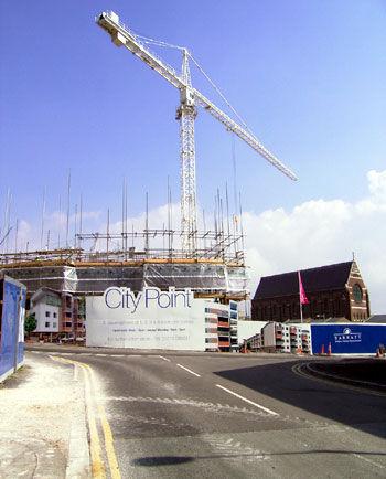
This photo shows the mainstay of the Citypoint development viewed from the Cheapside / New England Street junction, looking due north.

BELOW: This photo shows the cut-through to the courtyard area immediately outside the new Sainsburys.

BELOW: As has been mentioned elsewhere in this project, New England Road was extensively broken up and part pedestrianised in the course of the site redevelopment. This area is just past CCK and just beyond the entrance to the NCP car park behind London Road Shops.

BELOW: This is the courtyard area just inside the V to the rear of the tower at the apex of the Citypoint block. The rear of the tower can be seen dead centre of the photo.

BELOW: This is the tower at the apex of the Citypoint and Sainburys block.

BELOW: This is the Citypoint tower looking roughly north-east, befor the creation of the onebrighton site opposite, facing the existing tower. New England House can be seen to the left of the photo, behind the hoardings for onebrighton.